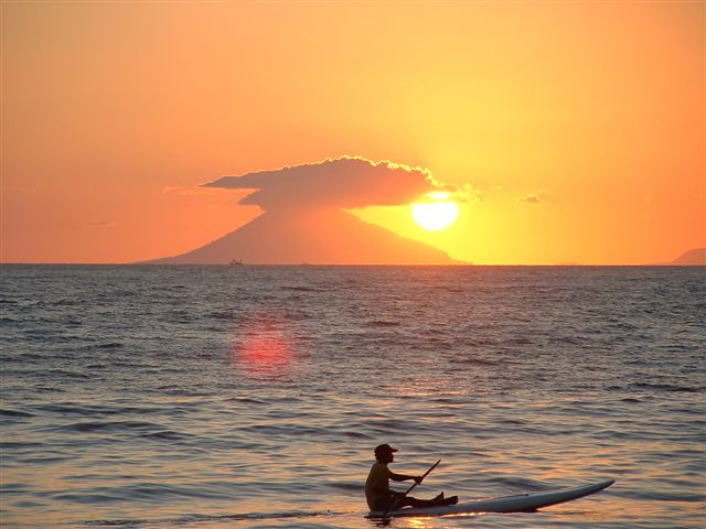
 Krakatoa , also spelled Krakatao or Krakatowa, is a volcanic island in the Sunda Strait between Java and Sumatra in Indonesia. The name is used for the island group, the main island (also called Rakata), and the volcano as a whole. It has erupted repeatedly, massively, and with disastrous consequences throughout recorded history. The best known eruption culminated in a series of massive explosions on August 26 - 27, 1883, which was among the most violent volcanic events in modern times. With a Volcanic Explosivity Index of 6, it was equivalent to 200 megatons of TNT — about 13,000 times the yield of the Little Boy bomb (13 to 16 KT) that devastated Hiroshima, Japan.
 The 1883 eruption ejected more than 25 cubic kilometres of rock, ash, and pumice, and generated the loudest sound historically reported: the cataclysmic explosion was distinctly heard as far away as Perth in Australia approx. 1,930 miles (3,110 km), and the island of Rodrigues near Mauritius approx. 3,000 miles (5,000 km). Near Krakatoa, according to official records, 165 villages and towns were destroyed and 132 seriously damaged, at least 36,417 (official toll) people died, and many thousands were injured by the eruption, mostly from the tsunamis that followed the explosion.
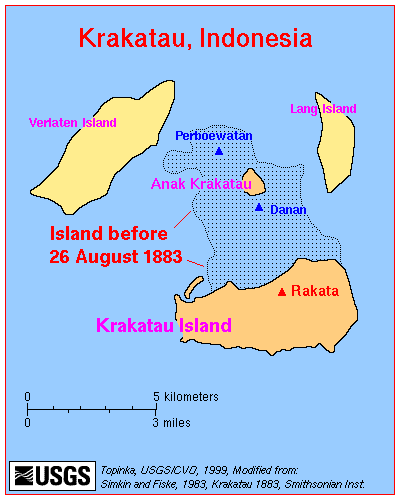
The eruption destroyed two-thirds of the island of Krakatoa. Eruptions at the volcano since 1927 have built a new island in the same location, called Anak Krakatau (child of Krakatoa).This island has a radius of roughly 2 kilometers and a high point around 200 meters above sea level. The original island of Krakatoa had a high point at an estimated 2000 meters above sea level and had a radius of 9 kilometers.
 Early eruptions
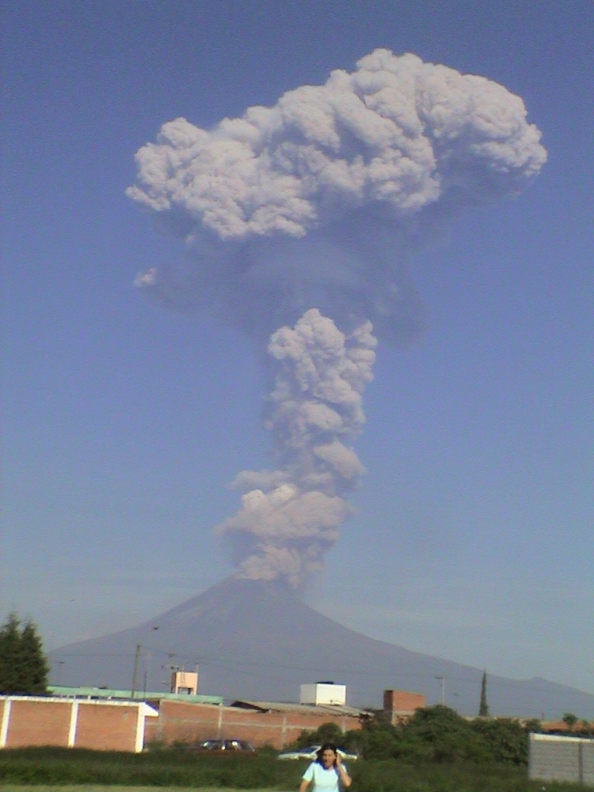
In the years before the 1883 eruption, seismic activity around the volcano was intense, with some earthquakes felt as far distant as Australia. Beginning 20 May 1883, three months before the final explosion, steam venting began to occur regularly from Perboewatan, the northernmost of the island's three cones. Eruptions of ash reached an altitude of 6 km (20,000 ft) and explosions could be heard in Batavia (Jakarta) 160 km (100 miles) away. Activity died down by the end of May.
The volcano began erupting again around 20 July. The seat of the eruption is believed to have been a new vent or vents which formed between Perboewatan and Danan, more or less where the current volcanic cone of Anak Krakatau is. The violence of the eruption caused tides in the vicinity to be unusually high, and ships at anchor had to be moored with chains as a result. On 11 August larger eruptions began, with ashy plumes being emitted from at least eleven vents. On 24 August, eruptions further intensified. At about 1pm (local time) on 26 August, the volcano went into its paroxysmal phase, and by 2pm observers could see a black cloud of ash 27 km (17 miles) high. At this point, the eruption was virtually continuous and explosions could be heard every ten minutes or so. Ships within 20 km (11 nautical miles) of the volcano reported heavy ash fall, with pieces of hot pumice up to 10 cm in diameter landing on their decks. A small tsunami hit the shores of Java and Sumatra some 40 km (28 miles) away between 6pm and 7pm.
 Cataclysmic stage
On August 27, the volcano entered the final cataclysmic stage of its eruption. Four enormous explosions took place at 05:30 hrs, 06:42 hrs, 08:20 hrs, and 10:02 hrs - all times are local. The last explosion was the loudest. Each was accompanied by very large tsunamis and are believed to have been over 30 meters (100 ft) high in places. A large area of the Sunda Strait and a number of places on the Sumatran coast were affected by pyroclastic flows from the volcano. The explosions were so violent that they were heard 3,500 km away in Perth, Western Australia and the island of Rodrigues near Mauritius, 4,800 km away; the sound of Krakatoa's destruction is the loudest sound in recorded history, reaching levels of 180 dBSPL 100 miles (160 km) away.. The pressure wave from the final explosion was recorded on barographs around the world and can be clearly identified as occurring at seven distinct intervals. Ash was propelled to a height of 80 km. The eruptions diminished rapidly after that point, and by the morning of August 28 Krakatoa was quiet.
 "The Burning Ashes of Ketimbang"
Around noon on August 27, a rain of hot ash fell around Ketimbang in Sumatra. Around a thousand people were killed, the only large number of victims killed by Krakatoa itself, and not the waves or after-effects. Verbeek and later writers believe this unique event was a lateral blast or pyroclastic flow, similar to what happened in 1980 at Mt. St. Helens, which crossed the water. The region of the ashfall ended to the northwest of Ketimbang, where the bulk of Sebesi Island offered protection from any horizontal surges.
 After eruptions
Small eruptions continued through October, and were reported through February 1884 (although any after mid October were discounted by Verbeek). In the aftermath of the eruption, it was found that the island of Krakatoa had almost entirely disappeared, except for the southern half of Rakata cone cut off along a vertical cliff, leaving behind a 250-meter-deep caldera.
Effects
The combined effects of pyroclastic flows, volcanic ashes and tsunamis had disastrous results in the region. There were no survivors from 3,000 people located at the island of Sebesi, about 13 km from Krakatoa. Pyroclastic flows killed around 1,000 people at Ketimbang on the coast of Sumatra some 40 km north from Krakatoa. The official death toll recorded by the Dutch authorities was 36,417, although some sources put the estimate at 120,000 or more. Many settlements were destroyed, including Teluk Betung and Ketimbang in Sumatra, and Sirik and Semarang in Java. The areas of Banten on Java and the Lampung on Sumatra were devastated. There are numerous documented reports of groups of human skeletons floating across the Indian Ocean on rafts of volcanic pumice and washing up on the east coast of Africa, up to a year after the eruption. Some land on Java was never repopulated; it reverted to jungle and is now the Ujung Kulon National Park.
 Tsunamis and distant effects
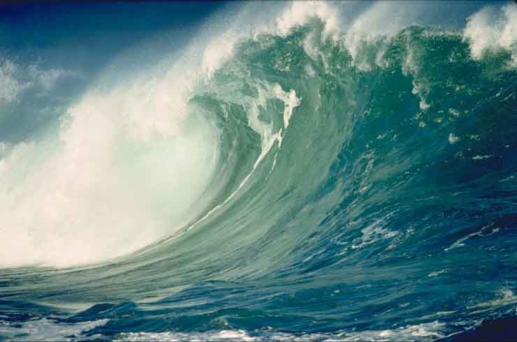
Ships as far away as South Africa rocked as tsunamis hit them, and the bodies of victims were found floating in the ocean for weeks after the event. The tsunamis which accompanied the eruption are believed to have been caused by gigantic pyroclastic flows entering the sea; each of the five great explosions was accompanied by a massive pyroclastic flow resulting from the gravitational collapse of the eruption column. This caused several cubic kilometers of material to enter the sea, displacing an equally huge volume of seawater. The town Merak was destroyed by a 46 metre-high tsunami. Some of the pyroclastic flows reached the Sumatran coast as much as 25 miles (40 km) away, having apparently moved across the water on a "cushion" of superheated steam. There are also indications of submarine pyroclastic flows reaching 10 miles (15 km) from the volcano.
A recent documentary film showed tests made by a research team at Kiel University, Germany of pyroclastic flows moving over water. The tests revealed that hot ash traveled over the water on a cloud of superheated steam, continuing to be a pyroclastic flow after crossing water; the heavy matter precipitated out of the flow shortly after initial contact with the water, creating a tsunami due to the precipitate mass.
Smaller waves were recorded on tidal gauges as far away as the English Channel. These occurred too soon to be remnants of the initial tsunamis, and may have been caused by concussive air waves from the eruption. These air waves circled the globe several times and were still detectable using barographs five days later.
 Geographic effects
As a result of the huge amount of material deposited by the volcano, the surrounding ocean floor was drastically altered. It is estimated that as much as 18-21 km³ of ignimbrite was deposited over an area of 1.1 million km², largely filling the 30-40 m deep basin around Krakatoa. The land masses of Verlaten and Lang were increased, and volcanic ash continues to be a significant part of the geological composition of these islands. Poolsche Hoed ("Polish Hat") disappeared. A new rock islet called Bootsmansrots ('Bosun's Rock', a fragment of Danan) was left.
Two nearby sandbanks (called Steers and Calmeyer after the two naval officers who investigated them) were built up into islands by ashfall, but the sea later washed them away. Seawater on hot volcanic deposits on Steers and Calmeyer caused steam which some people mistook for continued eruption.
The fate of Krakatoa itself has been the subject of some dispute among geologists. It was originally proposed that the island had been blown apart by the force of the eruption. However, most of the material deposited by the volcano is clearly magmatic in origin and the caldera formed by the eruption is not extensively filled with deposits from the 1883 eruption. This indicates that the island subsided into an empty magma chamber at the end of the eruption sequence, rather than having been destroyed during the eruptions.
Global climate
In the year following the eruption, average global temperatures fell by as much as 1.2 degrees Celsius. Weather patterns continued to be chaotic for years, and temperatures did not return to normal until 1888. The eruption injected an unusually large amount of sulfur dioxide (SO2) gas high into the stratosphere which was subsequently transported by high-level winds all over the planet. This led to a global increase in sulfurous acid (H2SO3) concentration in high-level cirrus clouds. The resulting increase in cloud reflectivity (or albedo) would reflect more incoming light from the sun than usual, and cool the entire planet until the suspended sulfur fell to the ground as acid precipitation.
Global optical effects
The eruption darkened the sky for days afterwards, and produced spectacular sunsets throughout the world for many months. British artist William Ashcroft made thousands of colour sketches of the red sunsets half-way around the world from Krakatoa in the years after the eruption. In 2004, researchers proposed the idea that the blood-red sky shown in Edvard Munch's famous 1893 painting The Scream is also an accurate depiction of the sky over Norway after the eruption. Munch said: "suddenly the sky turned blood red ... I stood there shaking with fear and felt an endless scream passing through nature." Also, a so called blue moon had been seen for two years as a result of the eruption.
Possible causes
The cause of the violent explosions has also attracted debate. Four theories are:
- Contemporary investigators believed that the volcano's vents had sunk below sea level on the morning of 27 August, letting seawater flood into it and causing a massive series of phreatic (interaction of ground water and magma) explosions.
- The seawater could have chilled the magma, causing it to crust over and producing a "pressure cooker" effect relieved only when explosive pressures were reached.
Both these ideas assumed that the island subsided before the explosions; however, the evidence does not support that conclusion and the pumice and ignimbrite deposits are not of a kind consistent with a magma-seawater interaction.
- A massive underwater land slump or partial subsidence suddenly left the highly pressurized magma chamber wide open.
- The final explosions may have been caused by magma mixing caused by a sudden infusion of hot basaltic magma into the cooler and lighter magma in the chamber below the volcano. This would have resulted in a rapid and unsustainable increase in pressure, leading to a cataclysmic explosion. Evidence for this theory is the existence of pumice consisting of light and dark material, the dark material being of much hotter origin. However, such material reportedly is less than 5% of the content of the Krakatoa ignimbrite and some investigators have rejected this as a prime cause of the 27 August explosions.
Verbeek investigation
Although the violent engulfment phase of the eruption was over by late afternoon of August 27, after light returned by the 29th, reports continued for months that Krakatoa was still in eruption. One of the earliest duties of Verbeek's committee was to determine if this was true and also verify reports of other volcanoes erupting on Java and Sumatra. In general, these were found to be false, and Verbeek discounted any claims of Krakatoa still erupting after mid October as due to steaming of hot material, landslides due to heavy monsoon rains that season, and "hallucinations due to electrical activity" seen from a distance.
No signs of activity were seen in the next several years until 1913, when an eruption was reported. Investigation could find no evidence the volcano was awakening, and it was determined that what had been mistaken for renewed activity had actually been a major landslide (possibly the one which formed the second arc to Rakata's cliff).
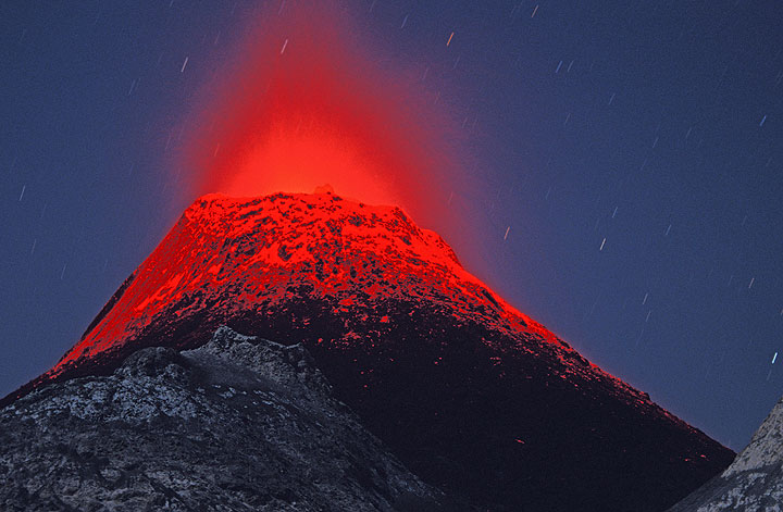
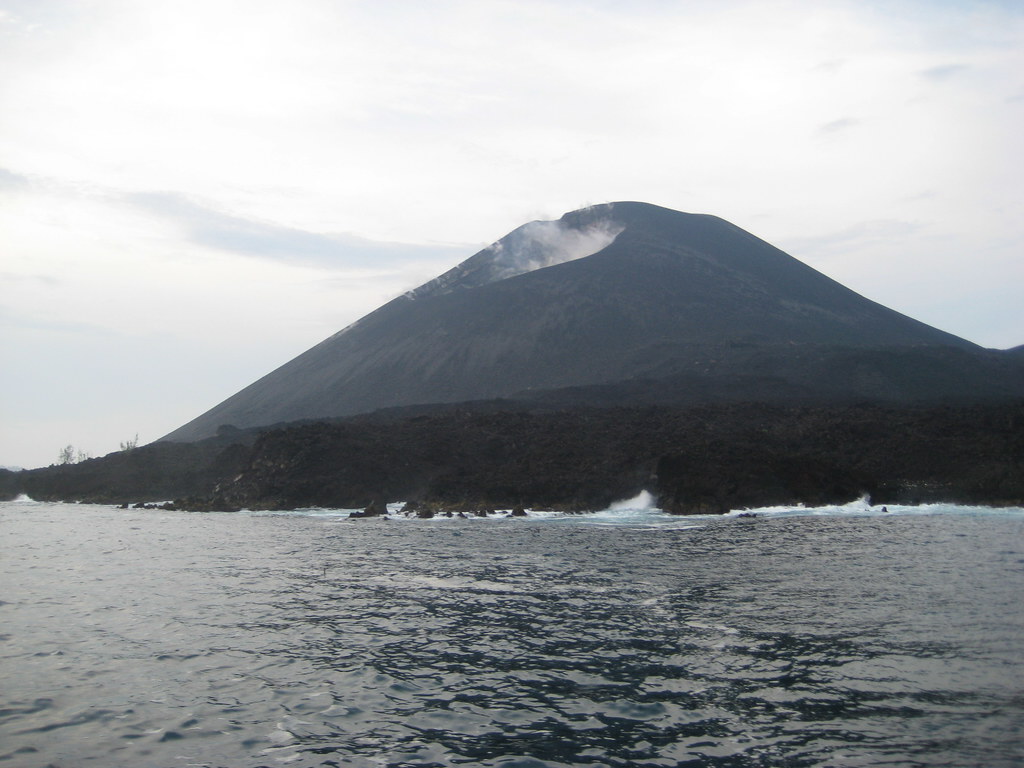
Anak Krakatau
Verbeek, in his report on the eruption, predicted that any new activity would manifest itself in the region which had been between Perboewatan and Danan. This prediction came true in June 1927 when evidence of a submarine eruption was seen in this area. A few days later, a new island volcano, named Anak Krakatau ("Child of Krakatoa"), broke water. Initially, the eruptions were of pumice and ash, and it (and 2 more islands) was quickly eroded away by the sea; but eventually Anak Krakatoa #4 produced lava flows faster than the waves could erode them. Of considerable interest to volcanologists, this has been the subject of extensive study since the new island broke water permanently in August 1930
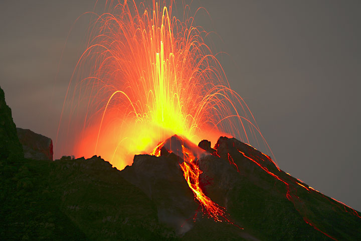
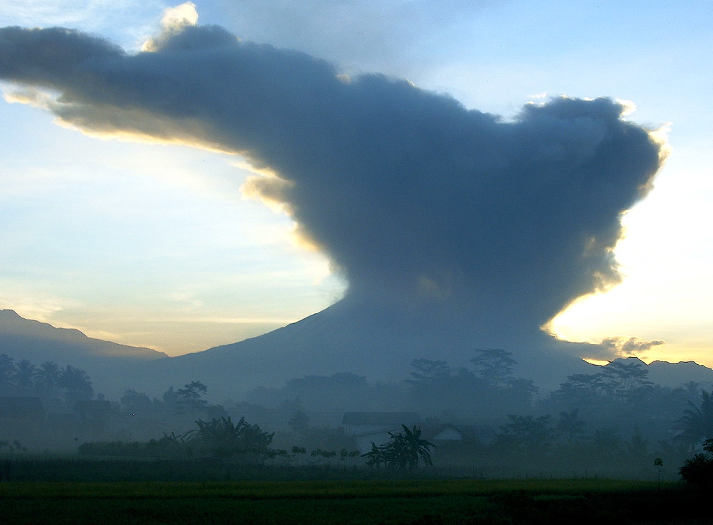
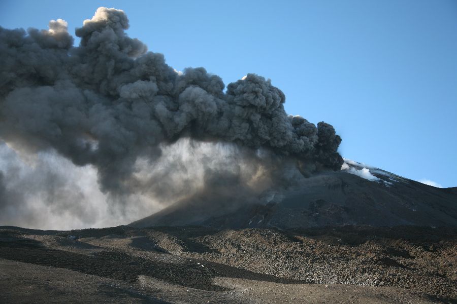
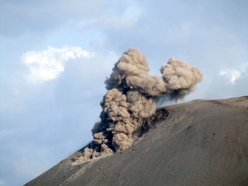
Current activity
The island is still active, with its most recent eruptive episode having begun in 1994. Since then, quiet periods of a few days have alternated with almost continuous eruptions, with occasional much larger explosions. Since the 1950s, the island has grown at an average rate of five inches (13 cm) per week. This volcano started erupting again in October and November 2007, when hot gases, rocks, and lava were released. Scientists monitoring the volcano have warned people to stay out of a 3 km zone around the island.
credited to wikipedia and flickr users: hida, flydime, nothingdestroyed, nadinexf, volcanoes
 Ailsa Craig is an island in the outer Firth of Clyde, Scotland where granite was quarried to make curling stones. "Ailsa" is pronounced "ale-sa", with the first syllable stressed.